


col épine

Henri.Vekemans
User
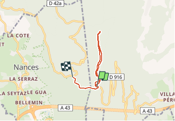

Length
4.6 km

Max alt
1043 m

Uphill gradient
103 m
Km-Effort
6.1 km

Min alt
937 m

Downhill gradient
150 m
Boucle
No
Creation date :
2021-04-17 14:12:28.546
Updated on :
2021-04-17 15:06:44.522
53m
Difficulty : Medium

FREE GPS app for hiking
 SityTrail
IGN / Geographical institutes
SityTrail Plus
The world is yours!
About
Trail Walking of 4.6 km to be discovered at Auvergne-Rhône-Alpes, Savoy, La Motte-Servolex. This trail is proposed by Henri.Vekemans.
Positioning
Country:
France
Region :
Auvergne-Rhône-Alpes
Department/Province :
Savoy
Municipality :
La Motte-Servolex
Location:
Unknown
Start:(Dec)
Start:(UTM)
720083 ; 5051784 (31T) N.
Comments